Professional Survey Services – Precision in Every Measurement
Welcome to Professional Survey Services, Malta’s leading provider of accurate and reliable surveying solutions. We specialize in offering a wide range of professional surveying services tailored to meet the diverse needs of construction firms, architects, developers, engineers, and private clients. With cutting-edge technology, experienced professionals, and a commitment to precision, Professional Survey Services ensures that every project starts with a solid foundation of accurate data.
From land and topographical surveys to boundary delineation and 3D mapping, we deliver comprehensive surveying solutions that drive successful project outcomes. Our team takes pride in providing services that meet the highest industry standards, combining technical expertise with a customer-centric approach.
Our Services
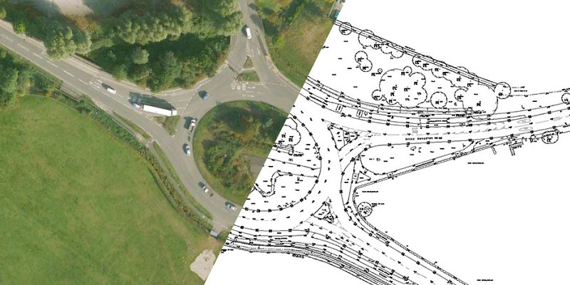
Land and Topographical Surveys
Accurate land and topographical surveys are essential for planning and executing any construction or development project.
- Detailed Site Analysis: Comprehensive surveys that provide essential data on land contours, boundaries, and existing structures.
- Elevation and Contour Mapping: High-precision measurements that aid in designing buildings, roads, and infrastructure.
- Geospatial Data Collection: Accurate geographical data collection for effective land use planning.
- Digital Mapping: Delivery of topographical data in digital formats compatible with CAD and BIM software.
Our land and topographical surveys provide the precise data necessary for informed decision-making and successful project execution.
Boundary Surveys
Defining and verifying property boundaries is critical for legal purposes and project planning.
- Boundary Identification: Accurate determination of property lines to prevent disputes.
- Subdivision Surveys: Planning and mapping for the division of land into multiple lots.
- Title Deed Verification: Ensuring that surveyed boundaries align with official property documentation.
- Legal Documentation Support: Preparation of survey reports for use in legal transactions and property disputes.
With our expert boundary surveys, clients gain clarity and confidence in property ownership and land development projects.
Construction Surveys
Precise surveying is crucial for the successful execution of construction projects, ensuring accuracy at every stage.
- Site Set-Out Surveys: Marking the exact location of proposed structures, ensuring alignment with design specifications.
- As-Built Surveys: Documenting completed projects to confirm adherence to design plans.
- Structural Monitoring: Ongoing monitoring of structural movement during construction to ensure safety and compliance.
- Utility Surveys: Mapping of underground utilities to prevent costly and dangerous disruptions during construction.
Our construction surveying services provide the precise data required for safe, efficient, and compliant building projects.
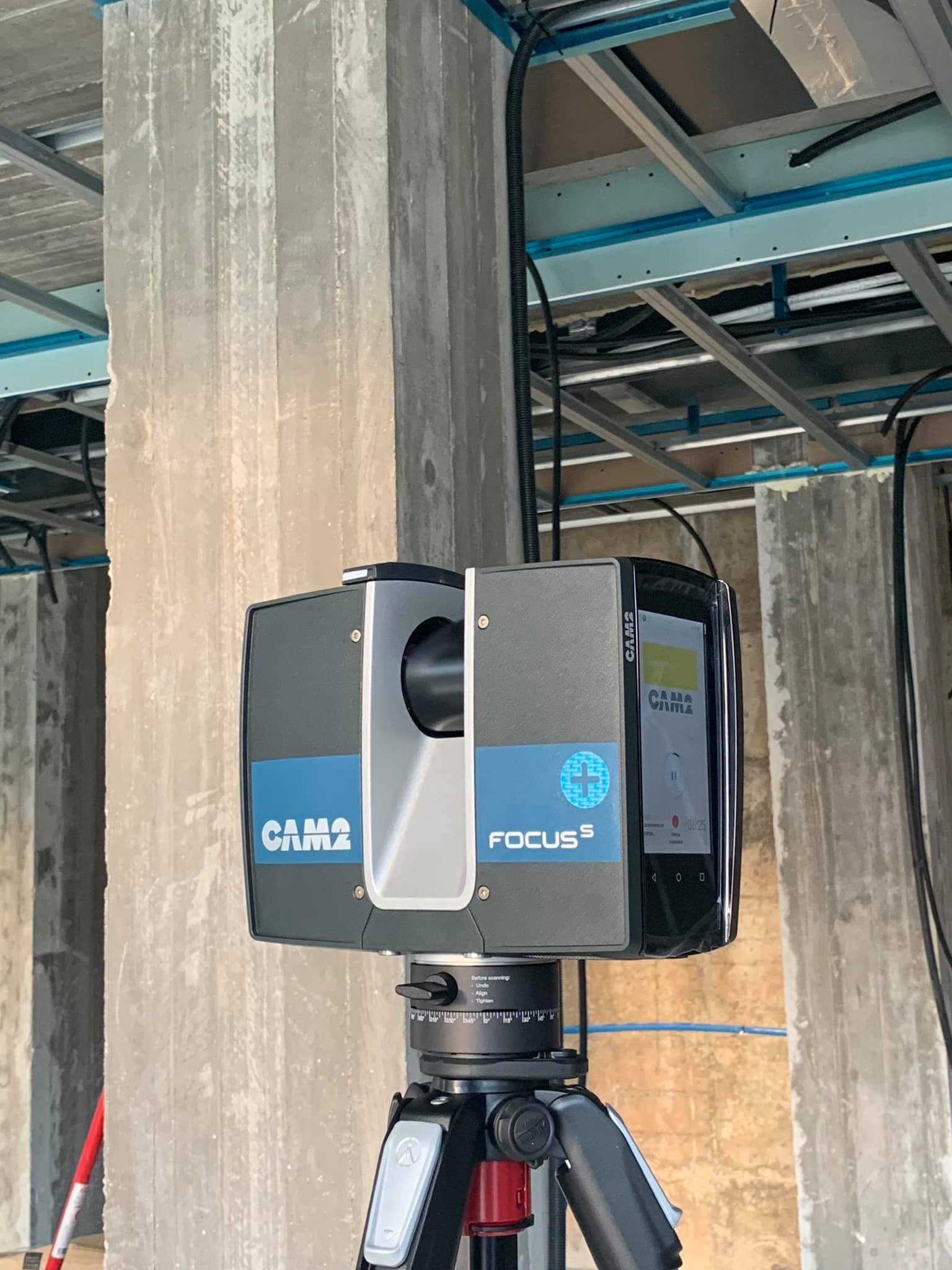
3D Laser Scanning and Modelling
Embrace the future of surveying with our advanced 3D laser scanning and modelling services.
- High-Definition Surveys: Capture detailed, accurate 3D representations of existing structures and environments.
- Point Cloud Data Processing: Conversion of scanned data into usable 3D models for architectural and engineering purposes.
- BIM Integration: Incorporation of 3D survey data into Building Information Modeling systems for comprehensive project management.
- Heritage and Restoration Projects: Detailed documentation of historical structures for preservation and restoration efforts.
Our 3D scanning solutions provide highly detailed data that enhances design accuracy, reduces errors, and streamlines project timelines.
Hydrographic Surveys
For projects involving bodies of water, we offer precise hydrographic surveying solutions.
- Bathymetric Surveys: Measurement and mapping of underwater topography for marine construction, dredging, and navigation projects.
- Shoreline Surveys: Accurate mapping of coastal areas for erosion control and infrastructure planning.
- Port and Marina Development: Surveying services to support safe and efficient port and marina operations.
- Environmental Impact Assessments: Data collection to assess potential impacts on aquatic environments.
Our hydrographic surveys ensure the safe and sustainable development of marine and waterfront projects.
Geodetic and Control Surveys
Establishing accurate reference points is essential for large-scale infrastructure and engineering projects.
- Control Point Establishment: Creation of reference points for long-term project accuracy.
- Geodetic Measurements: Precise data collection using advanced GPS and GNSS technology.
- Alignment and Deformation Monitoring: Monitoring infrastructure for structural integrity and alignment over time.
- National Grid Integration: Surveys aligned with national grid systems for compatibility with government and industry standards.
Our geodetic surveys provide the foundational data necessary for large-scale projects that demand absolute precision.
Why Choose Professional Survey Services?
Unmatched Precision
We use state-of-the-art equipment and the latest surveying techniques to deliver highly accurate data that meets industry standards.
Experienced Professionals
Our team consists of certified surveyors with extensive experience across various sectors, ensuring expert guidance and reliable results.
Comprehensive Solutions
From initial site surveys to final as-built documentation, we offer a full range of surveying services tailored to each client’s needs.
Client-Centric Approach
We take pride in our responsive service, clear communication, and commitment to understanding and meeting client objectives.
Advanced Technology
We leverage cutting-edge technology, including GPS, GNSS, drones, and 3D laser scanning, to provide precise and efficient survey results.
Timely Delivery
We understand the importance of deadlines. Our streamlined processes and skilled team ensure all projects are delivered on time and within budget.
Who We Serve
Architects and Designers
Providing the accurate data needed for effective planning, design, and execution of construction projects.
Construction Companies
Supporting construction projects with precise set-outs, monitoring, and compliance surveys.
Property Developers
Offering boundary and subdivision surveys that simplify the development and sale of real estate projects.
Government and Municipal Authorities
Delivering geodetic and infrastructure surveys to support public works and urban planning.
Marine and Port Authorities
Providing hydrographic surveys essential for safe and efficient marine infrastructure development.
Professional Survey Services – Precision You Can Build On
Discover why leading developers, architects, and construction firms across Malta trust Professional Survey Services for their surveying needs. Our combination of experience, advanced technology, and commitment to excellence ensures that every project we undertake is built on a foundation of accuracy and reliability.
Contact us today to schedule a consultation and let Professional Survey Services provide the precise data you need for your next project.